

How to Use a Service Cable Locator: A Professional Guide to Precision Detection
The difference between a seamless project and a catastrophic utility strike often rests in the delicate calibration of a single frequency. For the discerning professional, mastering how to use a service cable locator is less about simple proximity and more about the art of signal management. You likely recognize the tension that comes with inconsistent depth readings or the confusion of overlapping signals in a congested corridor. It's a high-stakes environment where the margin for error is non-existent, and the cost of a mistake is measured in both prestige and capital.
This guide provides the definitive methodology for achieving surgical precision in subsurface detection. We'll move beyond basic operation to explore the sophisticated techniques required for accurate 3D mapping and full compliance with the latest safety protocols. By refining your approach from passive sweeping to active, frequency-specific tracing, you'll gain the confidence to operate elite assets like Megger or high-end Radiodetection units. We'll examine the logic of multi-frequency settings and the nuances of depth verification, ensuring your next survey is a benchmark of reliability and technical excellence.
Key Takeaways
- Understand the core principles of electromagnetic induction and how the symbiotic relationship between transmitter and receiver ensures detection accuracy.
- Discern when to utilize passive sweeping for rapid identification versus active tracing for the surgical isolation of specific subsurface assets.
- Master the critical art of frequency selection, prioritizing lower ranges to maintain signal integrity and prevent hazardous bleeding onto adjacent utilities.
- Gain a definitive, step-by-step sequence for how to use a service cable locator in complex environments, starting from the initial sweep to precise connection points.
- Elevate your operational standards by leveraging elite, NATA-traceable instrumentation from industry leaders to ensure absolute reliability on high-stakes projects.
Understanding the Fundamentals of Service Cable Location
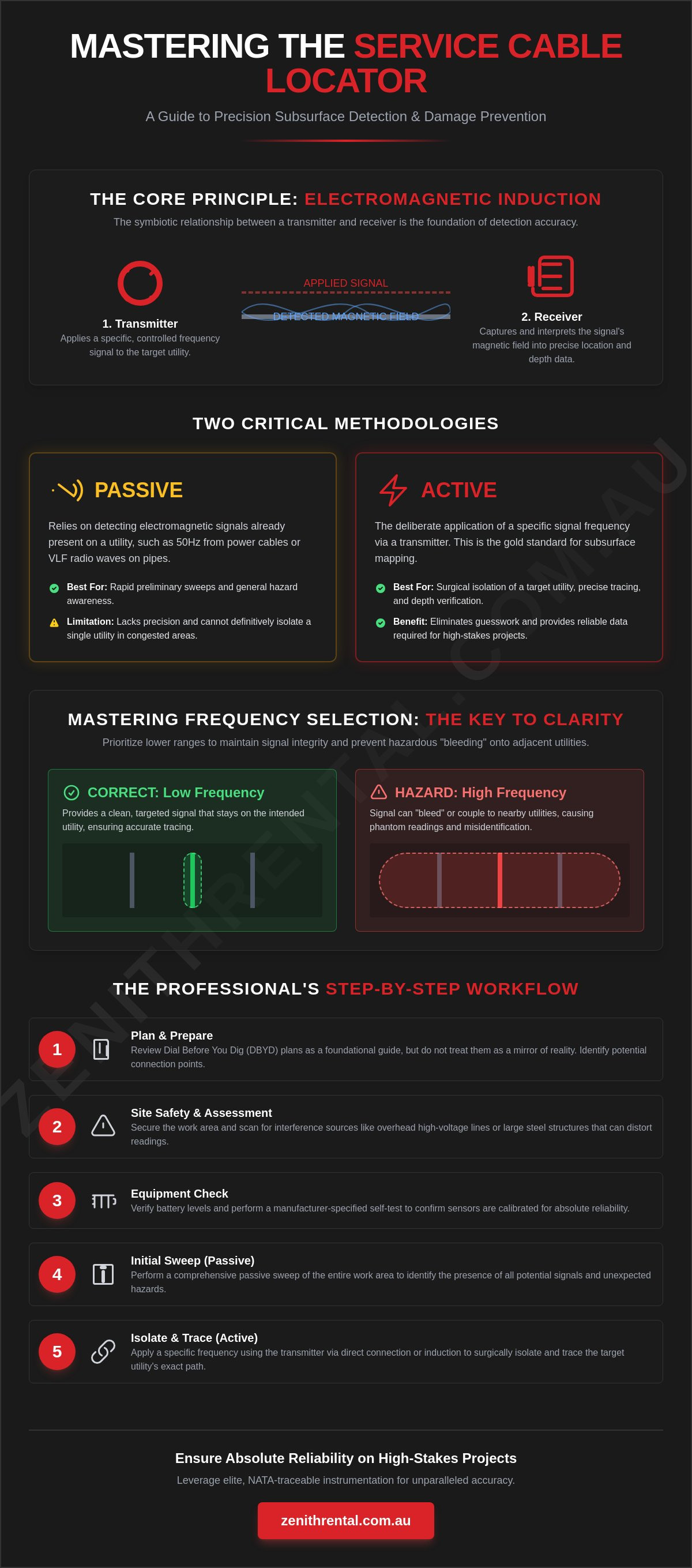
Precision in subsurface detection relies on the elegant principle of electromagnetic induction. This physical phenomenon allows a Cable locator to detect the invisible magnetic field surrounding a metallic conductor. It's a sophisticated process where physics meets practical field application. To master how to use a service cable locator, one must first respect the symbiotic relationship between its two primary components: the transmitter and the receiver. The transmitter, often referred to as a signal generator, applies a specific, controlled frequency to the target utility. The receiver then captures and interprets these signals, translating them into the precise depth and position data required for a successful survey.
In the Australian landscape, professional locating is governed by the rigorous standards of AS 5488 (Classification of Subsurface Utility Information). This framework provides a consistent lexicon for asset data quality, ranging from Quality Level D (derived from existing records) to the surgical accuracy of Quality Level A (positive identification via physical exposure). Adhering to these standards isn't just a matter of compliance. It's a commitment to the highest standard of service and project integrity. By classifying your findings within this system, you provide stakeholders with a clear, reliable map of the risks beneath their feet.
There is also a vital distinction to make between locating and tracing. Locating is the initial act of discovery, where you identify the presence of a signal within a specific work zone. Tracing, however, is the rhythmic and systematic process of following that signal's path across the site. Tracing requires a refined touch, as you must maintain a consistent signal lock to map the utility's exact trajectory. This methodology ensures that every bend, tee, and depth change is accounted for before the first bucket hits the ground.
The Importance of Dial Before You Dig (DBYD) Plans
Dial Before You Dig plans serve as your architectural foundation. They are the essential starting point for any precision survey, providing the context needed to identify potential entry points like pits, meters, or risers. However, it's critical to remember that plans are a guide, not a mirror of reality. Legacy plans in modern industrial environments often fail to reflect decades of upgrades or abandoned "ghost" services. Use these documents to inform your strategy, but rely on your instrumentation to confirm the truth of the terrain.
Safety Protocols and Site Preparation
Elite performance begins with an impeccable safety perimeter. Before the electronics engage, verify that the work area is secure and that all team members are briefed on the site's unique hazards. Scan the environment for interference sources; overhead high-voltage lines or large steel structures can distort electromagnetic fields and lead to phantom readings. Finally, ensure your assets are ready for the task. Verify battery levels and perform a manufacturer-specified self-test to confirm that your sensors are calibrated for absolute reliability.
Passive vs. Active Locating: Choosing Your Methodology
Selecting the appropriate methodology is the hallmark of a discerning technician. It's a choice that balances the need for rapid assessment with the absolute requirement for surgical precision. When considering how to use a service cable locator effectively, you must distinguish between passive and active detection. Passive locating relies on identifying electromagnetic signals already present on a utility, such as the 50Hz frequency emitted by live power cables or very low frequency (VLF) radio waves that naturally couple with metallic pipes. It's an excellent method for a preliminary sweep, but it lacks the definitive isolation required for high-stakes projects.
Active locating, by contrast, involves the deliberate application of a specific signal via a transmitter. This approach represents the gold standard in subsurface mapping. By introducing a known frequency, you can isolate a single utility from a crowded corridor of competing signals. Professional operators understand that while passive hits provide a starting point, they must always be verified through active tracing. This rigorous approach aligns with Common Ground Alliance Best Practices, which advocate for multi-layered verification to ensure the highest standard of damage prevention and site safety.
For those seeking to reach the peak of industry standards, professional Service Cable Locator hire provides access to the elite instrumentation required to execute these methodologies with total confidence. The ability to switch seamlessly between modes allows for a more rhythmic and logical survey process, minimizing friction and maximizing accuracy.
Passive Power and Radio Modes
Passive Power mode is specifically tuned to detect the electromagnetic field generated by live, loaded electricity cables. It's a fast, non-invasive way to identify immediate hazards. Radio mode expands this capability by detecting long-wave radio signals that have "hitched a ride" on buried metallic assets. However, these modes are susceptible to "ghost signals" in congested urban areas. In these environments, signals often bleed between utilities, creating a deceptive map that can lead to inaccurate depth readings or misplaced markings.
Active Tracing: Induction vs. Direct Connection
Active tracing offers three primary modes of engagement, each suited to different site conditions:
- Direct Connection: This is the most accurate method available. By physically connecting the transmitter to a valve, meter, or de-energized line, you ensure the signal stays "locked" to the target asset.
- Signal Clamping: When you need to trace a live cable without interrupting service, a signal clamp is the preferred professional tool. It induces a signal through the insulation, providing a middle ground between induction and direct contact.
- Induction: This method uses the transmitter's internal antenna to broadcast a signal through the ground. It's useful when access points are unavailable, but it requires careful management to avoid energizing every metallic object in the vicinity.
Mastering Frequency Selection for Accurate Tracing
Frequency selection is the intellectual heart of subsurface detection. While basic units might offer a limited range, professional-grade assets provide a spectrum of choices that require a discerning eye. If you're refining your knowledge of how to use a service cable locator, you must understand that frequency is a delicate trade-off between signal distance and surgical isolation. The cardinal rule of the industry is to always select the lowest frequency that yields a stable, traceable signal. This disciplined approach ensures the signal remains locked to the target asset rather than wandering toward more attractive, lower-resistance paths nearby.
The environment itself dictates much of this strategy. Soil conductivity acts as the medium through which your signal travels, and it can be a fickle partner. Damp, mineral-rich clay might carry a low-frequency signal for miles with ease, whereas dry, sandy loam can resist signal penetration, forcing you to increase the frequency just to establish a workable circuit. However, with increased frequency comes increased risk. High frequencies possess a restless energy, often "bleeding" or coupling onto adjacent utilities. In a crowded utility corridor, this can lead to the dangerous misidentification of assets, where the technician unknowingly follows a secondary line instead of the primary target.
Low Frequencies (512Hz - 8kHz)
Low frequencies are the preferred choice for long-distance utility mapping and high-precision surveys. Their primary benefit is signal integrity; they're far less likely to jump across to parallel services, even in congested areas. Because they don't dissipate as quickly as their high-frequency counterparts, they can travel significant distances, sometimes several kilometers, from the point of connection. To utilize this range effectively, you generally require a clean, direct connection to the asset to overcome the initial resistance of the conductor, ensuring the signal is concentrated exactly where it belongs.
High Frequencies (33kHz - 131kHz)
There are moments when high frequencies are indispensable, particularly when dealing with poor grounding or small-diameter cables that don't easily accept a signal. This range is primarily used for induction-style locating, where the transmitter broadcasts a signal through the earth to the asset below. High frequencies can "jump" across insulators or poor mechanical joints that would stop a low-frequency signal entirely. The risk, however, is the "washout" effect. At these levels, the magnetic field can become broad and indistinct, making it difficult to achieve the 3D mapping accuracy required for elite project standards. Use these settings with caution and always verify your findings against known site plans.
Step-by-Step Operating Procedure for Field Technicians
Executing a precision survey is a disciplined ritual that transforms raw data into a reliable map of the unseen. To master how to use a service cable locator, you must approach the site with a methodical rhythm, ensuring no signal is left unverified. The process begins with a comprehensive passive sweep of the entire work area. This initial scan identifies "hot" zones where energized power or radio signals are already present, providing a preliminary sketch of the underground landscape before you even engage the transmitter. It's a vital step that prevents the accidental overlooking of live services that might not appear on your active trace.
Once the initial sweep is complete, connect your transmitter to a known access point, such as a utility pit, meter, or riser. This direct connection ensures the signal is concentrated on your target asset with maximum clarity. Select your frequency with the precision discussed in previous sections, then adjust the output power to suit the site's conductivity. With the transmitter active, move the receiver in a disciplined grid pattern across the suspected path. You aren't just walking; you're intersecting the buried service line at right angles to confirm its trajectory with surgical accuracy. This systematic intersection is the only way to guarantee you've captured the true center of the utility.
Achieving this level of confidence requires elite tools that have been maintained to the highest industry standards. For those who demand absolute reliability on every project, securing a Service Cable Locator hire ensures your team is equipped with calibrated, professional-grade instrumentation from leaders like Megger or Fluke. Using the right equipment eliminates the guesswork and mirrors the high performance your clients expect.
The Peak vs. Null Measurement Technique
Professional technicians utilize both Peak and Null modes to verify signal integrity. The Peak method identifies the highest signal strength directly over the cable, providing a clear "mountain" of data on your display. Conversely, the Null method produces a sharp signal drop exactly over the asset. If the Peak and Null positions don't align, it's a clear indicator of signal distortion caused by adjacent utilities or soil conditions. Only when both modes agree can you mark the ground with total confidence.
Estimating Depth and Verifying Accuracy
Modern receivers provide instantaneous digital depth readings, but these should always be treated as sophisticated estimates rather than absolute truths. To verify a reading, use the manual 45-degree rule: move the receiver to the side until the signal strength drops by half, and the distance from the center line will roughly equal the depth. This triangulation provides a vital cross-check, ensuring that your 3D mapping remains accurate even in challenging environments with high signal interference.
Marking and Documentation
Once pinpointed, mark the ground using the standard Australian utility colour codes. Use Red for electrical power, Yellow for gas, and Pink for general survey marks or temporary identification. It's not enough to mark a single point; you must clearly illustrate the direction of travel and any significant bends or tees. Finally, document your success by taking site photos of the markings relative to permanent landmarks, creating a digital record that provides peace of mind for the entire project lifecycle.
Ensuring Reliability with Elite Instrumentation Rental
Success in utility detection isn't just about technique; it's about the calibre of the instruments you carry. While mastering how to use a service cable locator is essential, even the most skilled technician is limited by the age and accuracy of their gear. Opting for test equipment hire Australia grants you immediate access to the latest innovations from industry leaders like Megger and Fluke. This strategy eliminates the heavy capital outlay associated with purchasing specialized locators that may become obsolete within a few years. Instead, you can focus your resources on project execution, knowing you're backed by the finest technology available.
For high-stakes industrial projects, the margin for error is non-existent. This is where NATA-traceable calibration becomes a critical component of your risk management strategy. A rented unit from a premium partner arrives with the certainty of recent, certified testing, ensuring that every depth reading and signal peak is beyond reproach. This level of reliability provides a sense of security and ease, reflecting a commitment to the highest possible standard of quality. It transforms a logistical necessity into a hallmark of professional excellence, positioning your brand as a high-tier partner for discerning clients.
The Zenith Standard of Equipment Excellence
Every asset undergoes a rigorous maintenance protocol before it reaches your site. We ensure that each locator is meticulously tested for sensitivity and signal clarity, mirroring the high performance required for complex 3D mapping. Modern units now feature seamless integration with GPS and cloud-based mapping software, allowing you to generate sophisticated digital reports that build trust with stakeholders. For projects requiring comprehensive site layout, our laser level hire services complement your subsurface data, providing a complete picture of the terrain with absolute precision.
Technical Support and On-Site Success
Choosing the right tool is the first step toward a flawless survey. While you've refined your knowledge of how to use a service cable locator for metallic services, certain sites may require the deeper penetration of Ground Penetrating Radar (GPR) for non-metallic assets. A dedicated instrumentation partner provides the technical guidance needed to make these critical distinctions. We offer the expertise to help you navigate complex measurement challenges, ensuring your team is never left guessing in the field. Our support is designed to minimize friction, allowing you to proceed with the confidence of an elite professional who has mastered the art of luxury service.
Explore our range of professional service cable locators for your next project and reach the peak of industry standards with absolute reliability.
Achieving Surgical Precision in Subsurface Detection
Precision in utility mapping is the hallmark of an elite professional. By mastering the transition from passive sweeps to active tracing and understanding the nuanced physics of frequency selection, you move beyond mere detection into the realm of sophisticated asset management. These methodologies ensure full compliance with safety protocols and protect both your professional reputation and the integrity of the site. Mastering how to use a service cable locator is a journey of continuous refinement, where technical knowledge meets high-performance instrumentation.
To maintain the highest standard of reliability, your team requires access to impeccably maintained, NATA-certified instrumentation. We invite you to Rent NATA-Calibrated Service Cable Locators from Zenith Rental, featuring elite brands such as Megger and Fluke. With our efficient Australia-wide shipping, the most refined tools in the industry are always within reach. This ensures your next project is executed with the absolute confidence that only premium technology can provide. Step into your next survey with the poise of a specialist who leaves nothing to chance.
Frequently Asked Questions
How accurate are service cable locators for depth estimation?
Digital depth readings are typically accurate within 5% to 10% of the actual depth when operating under ideal conditions with a clear signal. However, environmental factors such as soil moisture, mineral content, and signal distortion can influence these figures. To maintain the highest standard of precision, elite professionals always verify digital estimates using the manual 45-degree triangulation method described in our operating procedure.
Can a cable locator find non-metallic pipes like PVC or concrete?
Standard electromagnetic locators cannot detect non-conductive materials directly because they don't carry an electrical current. To map these assets, you must use a traceable rod or a sonde inserted into the line to broadcast a signal from within. Understanding how to use a service cable locator in these scenarios requires specialized accessories that turn a non-metallic void into a detectable electromagnetic target.
What is the difference between a cable locator and a pipe locator?
The distinction is primarily found in the accessories and frequency ranges rather than the underlying technology. While both use electromagnetic induction, a pipe locator is often packaged with sondes and clamps specifically designed for plumbing and drainage. Modern, high-end units from brands like Megger or Fluke are versatile enough to handle both tasks with equal sophistication, provided the operator selects the correct tracing mode.
Do I still need to hand-dig if I have used a cable locator?
Yes, positive identification through hand-digging or vacuum excavation is a non-negotiable safety requirement. Electronic detection provides a highly accurate map of the subsurface landscape, but it doesn't replace the need for physical verification. Hand-digging ensures you've accounted for every bend and depth change before heavy machinery begins work, protecting both the asset and your team's safety.
What causes signal distortion when using a locator?
Distortion typically occurs when the electromagnetic signal "bleeds" or couples onto nearby metallic objects, such as adjacent utility lines or steel-reinforced concrete. High-voltage overhead power lines and large metal structures can also warp the magnetic field. If your Peak and Null readings fail to align, it's a clear signal that interference is present, necessitating a shift to a lower frequency to regain tracing integrity.
Can I use a cable locator to find a fault in a buried wire?
While a standard locator identifies the path of a cable, pinpointing a specific break or insulation fault requires specialized equipment like an A-frame ground fault locator. These sophisticated tools detect where current is escaping into the earth, allowing for a surgical repair. Learning how to use a service cable locator with these advanced attachments is essential for high-stakes industrial maintenance where downtime must be minimized.
How often does a service cable locator need to be calibrated?
Professional-grade locators require NATA-traceable calibration at least once every 12 months to ensure absolute reliability. Regular calibration confirms that the internal sensors and depth-calculation logic remain within the manufacturer's strict tolerances. For high-stakes projects, using a recently calibrated unit from a premium rental partner is the most efficient way to guarantee that your site data meets the highest industry standards.